The Tibetan Plateau (TP), often referred to as the 'Asian Water Tower', plays a critical role in regulating the hydrological cycle and influencing global climate patterns. Its unique topography and climatic conditions result in pronounced seasonal freeze-thaw (FT) dynamics of the land surface, which are critical for understanding permafrost ecosystem responses to climate change. However, existing studies on FT dynamics over the TP are limited by either short observational periods or deficiency in accuracy, failing to capture the long-term FT processes comprehensively. This study presents a novel satellite-based approach for monitoring the FT dynamics over the TP from 1979 to 2022, utilizing passive microwave observations. We developed a new algorithm that integrates discriminant function algorithm (DFA) with a seasonal threshold algorithm (STA), employing the freeze-thaw index (FTI) as the classification variable to determine optimal FT thresholds. The strong performance of the algorithm was confirmed by in-situ validation, with an overall accuracy of 91.46%, a Kappa coefficient of 0.83, and an F1-score of 0.92, outperforming other remote sensing-derived FT products such as SMAP (OA = 89.44%, Kappa = 0.79, F1 = 0.89). Results reveal significant changes in surface freeze-thaw dynamics over the past four decades. Between 1988-2022, frozen days exhibited a significant decreasing trend of -0.19 daysyear(-)(1), primarily attributed to the delayed freeze onset (0.19 daysyear(-)(1)), while thaw onset showed no significant trend. Spatially, permafrost regions experienced a more pronounced decrease in frozen days and earlier thaw onset compared to seasonally frozen regions. Moreover, marked interannual trend differences in FT processes were observed across elevation gradients, with higher elevations showing more negative trends in frozen days and thaw onset. This study provides a reliable and up-to-date analysis of surface FT process changes over the TP, informed by long-term satellite-based observational perspectives. These analyses revealed marked spatial heterogeneity in surface FT dynamics across the TP region, underscoring the impacts of climate change on the cryosphere and hydrology.
Climate change is reshaping the risk landscape for natural gas pipelines, with landslides emerging as a major driver of technological accidents triggered by natural hazards (Natech events). Conventional Natech risk models rarely incorporate climate-sensitive parameters such as groundwater levels and soil moisture, limiting their capacity to capture evolving threats. This study develops a probabilistic model that explicitly links climate-driven landslide susceptibility to pipeline vulnerability, providing a quantitative basis for assessing pipeline failure probability under different emission projection scenarios. Using Monte Carlo simulations across five regions in China, the results show that under high-emission pathways (SSP5-8.5), pipeline failure probability in summer increases dramatically. For example, from 0.320 to 0.943 in Xinjiang, 0.112 to 0.220 in Sichuan, and 0.087 to 0.188 in Hainan. In cold regions, winter failure probability more than doubles, rising from 0.206 to 0.501 in Heilongjiang and from 0.235 to 0.488 in Beijing. These shifts reveal an overall increase in risk, intensification of seasonal contrasts, and, in some areas, a reconfiguration of high-risk periods. Sensitivity analysis highlights groundwater levels and soil moisture as the dominant drivers, with regional differences shaped by precipitation regimes, permafrost thaw, and typhoon impacts. Building on these insights, this study proposes an AI-based condition-monitoring framework that integrates real-time climate and geotechnical data to support adaptive early warning and safety management.
Study region The eastern Qilian Mountains, located on the northeastern margin of the Tibetan Plateau, span elevations from similar to 2600 to 5300 m around the Menyuan area. It is characterized by cold, alpine climatic conditions and hosts both permafrost and seasonally frozen ground, which are highly sensitive to climate change and have important hydrological and ecological implications. Study focus This study develops an enhanced multi-temporal InSAR framework to monitor frozen ground dynamics in the eastern Qilian Mountains using Sentinel-1 data from 2014 to 2024, with a particular focus on the permafrost-seasonally frozen ground transition zone around Menyuan. It addresses key challenges in permafrost monitoring by implementing a co-seismic deformation separation model, a Common Scene Stack (CSS)-based atmospheric correction method, and a time-series decomposition model with linearly varying annual amplitude to capture evolving freeze-thaw behavior under climate change. New hydrological insights for the region The results reveal clear hydrological and thermal contrasts between permafrost and seasonally frozen ground. Seasonally frozen ground exhibits higher seasonal deformation amplitudes, more rapid interannual changes, and shorter thermal response lags compared to permafrost, reflecting its more dynamic hydrothermal regime. The estimated freeze-thaw layer thickness ranges from 0 to 5.3 m, with thinning trends in seasonally frozen ground at lower elevations and slight thickening of active layers in high-elevation permafrost. These findings highlight ongoing frozen ground degradation and provide new insights into subsurface water-energy interactions and long-term cryospheric responses to climate warming in alpine environments.
Rapid climate change in the Northern Hemisphere cryosphere threatens ancient permafrost carbon. Once thawed, permafrost carbon may migrate to surface waters. However, the magnitude of permafrost carbon processed by northern freshwater remains uncertain. Here, we compiled '1800 radiocarbon data of aquatic dissolved organic carbon (DOC) and particulate organic carbon (POC) in the Arctic and Qinghai -Tibet Plateau (QTP) to explore the fate of permafrost carbon under climate warming over the past 30 years. We showed that the contribution of aged carbon has significantly increased since 2015. Approximately 70 % of DOC and POC was derived from aged carbon for QTP rivers. In Arctic waters, an average of '67 % of POC was derived from aged carbon, however, '75 % of DOC was derived from modern carbon, mainly due to low temperatures and protection by vegetation limiting the export of aged DOC. For both regions, DOC 14 C age was positively correlated with the active layer thickness, whereas the POC 14 C age was positively correlated with the mean annual ground temperature, suggesting that gradual thaw accelerated the mobilization of aged DOC while abrupt thaw facilitated the export of aged POC. Furthermore, POC 14 C age was positively correlated with the soil organic carbon density, which was attributed to well-developed pore networks facilitated aged carbon output. This study suggests that permafrost carbon release is affected by both permafrost thermal properties and soil organic carbon density, which should be considered in evaluation of permafrost carbon -climate feedback.
Black carbon (BC) mixed with non-BC components strongly absorbs visible light and leads to uncertainty in assessing the absorption enhancement (Eabs) and thus radiative forcing. Traditional Single-Particle Soot Photometer (SP2) combined with the leading-edge only fitting (the only-SP2 method) derives BC's mixing states through Mie scattering calculations. However, errors exist in retrieved optical diameter (Dopt) and MR due to the assumption of the ideal spherical core-shell structure and the selection of the calculation parameters like density and refractive index (RI) of the components. Here, we employed a custom-developed tandem CPMA-SP2 system, which classifies fixed-mass BC to characterize the mixing state, then compared with the only-SP2 method in quantifying the mixing state and Eabs. The field measurements show that the SP2 demonstrates variability in assessing the mixing state of BC in different aging states. The thickly-coated particles with small core approaching the internally mixed state are more sensitive to the change of calculated RI. The Dopt decreases with the RI increasing, indicating that this method accurately measures both Dopt and Eabs when a reasonable refractive index is selected for calculation. However, for thinly-coated particles with moderate or large core, this method results in significant deviations in the computed Eabs (errors up to 15 %). These deviations may be caused by the various shapes of BC and systematic errors. Our results provide valuable insights into the accuracy of the SP2-retrieved Dopt and MR based on Mie calculations and highlight the importance of employing advanced techniques for further assessment of BC's mixing state.
Permafrost soils contain approximately twice the amount of carbon as the atmosphere and this carbon could be released with Arctic warming, further impacting climate. Mosses are major component of Arctic tundra ecosystems, but the environmental drivers controlling heat penetration though the moss layer and into the soil and permafrost are still debated, especially at fine spatial scales where microtopography impacts both vegetation and soil moisture. This study measured soil temperature profiles (1-15 cm), summer thaw depth, water table depth, soil moisture, and moss thickness at a fine spatial scale (2 m) together with meteorological variables to identify the most important controls on the development of the thaw depth during two Arctic summers. We found a negative relationship between the green moss thickness (up to 3 cm) and the soil temperatures at 15 cm, suggesting that mosses insulated the soil even at high volumetric water contents (>70%) in the top 5 cm. A drier top (2-3 cm) green moss layer better insulated deep (15 cm) soil layers by reducing soil thermal conductivity, even if the moss layers immediately below the top layer were saturated. The thickness of the top green moss layer had the strongest relationships with deeper soil temperatures, suggesting that the top layer had the most relevant role in regulating heat transfer into deeper soils. Further drying of the top green moss layer could better insulate the soil and prevent permafrost thawing, representing a negative feedback on climate warming, but damage or loss of the moss layer due to drought or fire could reduce its insulating effects and release carbon stored in the permafrost, representing a positive feedback to climate warming.
Large-scale wildfires are essential sources of black carbon (BC) and brown carbon (BrC), affecting aerosol-induced radiative forcing. This study investigated the impact of two wildfire plumes (Plume 1 and 2) transported to Moscow on the optical properties of BC and BrC during August 2022. During the wildfires, the total light absorption at 370 nm (b(abs_370nm)) increased 2.3-3.4 times relative to background (17.30 +/- 13.98 Mm(-)(1)), and the BrC contribution to total absorption increased from 14 % to 42-48 %. BrC was further partitioned into primary (BrCPri) and secondary (BrCSec) components. Biomass burning accounted for similar to 83-90 % of BrCPri during the wildfires. The b(abs_370nm) of BrCPri increased 5.6 times in Plume 1 and 11.5 times in Plume 2, due to the higher prevalence of peat combustion in Plume 2. b(abs_370nm) of BrCSec increased 8.3-9.6 times, driven by aqueous-phase processing, as evidenced by strong correlations between aerosol liquid water content and b(abs_370nm) of BrCSec. Daytime b(abs_370nm) of BrCSec increased 7.6 times in Plume 1 but only 3.6 times in Plume 2, due to more extensive photobleaching, as indicated by negative correlations with oxidant concentrations and longer transport times. The radiative forcing of BrCPri relative to BC increased 1.8 times in Plume 1 and Plume 2. In contrast, this increase for BrCSec was 3.4 times in Plume 1 but only 2.3 times in Plume 2, due to differences in chemical processes, which may result in higher uncertainty in its radiative forcing. Future work should prioritize elucidating both the emissions and atmospheric processes to better quantify wildfire-derived BrC and its radiative forcing.
Soil organic matter (SOM) stability in Arctic soils is a key factor influencing carbon sequestration and greenhouse gas emissions, particularly in the context of climate change. Despite numerous studies on carbon stocks in the Arctic, a significant knowledge gap remains regarding the mechanisms of SOM stabilization and their impact on the quantity and quality of SOM across different tundra vegetation types. The main aim of this study was to determine SOM characteristics in surface horizons of permafrost-affected soils covered with different tundra vegetation types (pioneer tundra, arctic meadow, moss tundra, and heath tundra) in the central part of Spitsbergen (Svalbard). Physical fractionation was used to separate SOM into POM (particulate organic matter) and MAOM (mineral-associated organic matter) fractions, while particle-size fractionation was applied to evaluate SOM distribution and composition in sand, silt, and clay fractions. The results indicate that in topsoils under heath tundra POM fractions dominate the carbon and nitrogen pools, whereas in pioneer tundra topsoils, the majority of the carbon and nitrogen are stored in MAOM fractions. Moreover, a substantial proportion of SOM is occluded within macro-and microaggregates. Furthermore, the results obtained from FTIR analysis revealed substantial differences in the chemical properties of individual soil fractions, both concerning the degree of occlusion in aggregates and across particle size fractions. This study provides clear evidence that tundra vegetation types significantly influence both the spatial distribution and chemical composition of SOM in the topsoils of central Spitsbergen.
This study investigated the principal factors governing natural ice melting through controlled experiments near the phase transition temperature (0 degrees C). The process of ice melting plays an important role in understanding glacier retreat and sea-level rise. The experimental results revealed that ice melting is mainly driven by conductive heat transfer from the attached substrate, accounting for 90.62% of the total melting rate, while solar radiation contributes only 9.38%. The study also highlights how rising temperatures intensify heat convection. When the environmental temperature rises by five degrees, the contribution of heat convection increases greatly, resulting in the melting rates of both soil-attached and non-attached ice samples being comparable and convective heat transfer becomes the main factor in the melting of ice. The findings point to a potential link between global warming and accelerated ice melting, with broader implications for glacier retreat and sea-level rise. We performed inelastic neutron scattering experiment as well as first-principles density functional theory calculation of ordinary ice phase, ice Ih. The comparison between the solar radiation spectrum and the vibrational spectrum of ice demonstrated that the main ice vibrational peaks fall far beyond the solar radiation range. This indicates that solar radiation absorption involves non-resonant photon-phonon coupling. Based on the thermal conductivity data of the substances, this study suggests that the photon-phonon resonant absorption (PPRA) photothermal convention method could increase by at least two orders of magnitude than traditional heat conduction method in the field of de-icing efficiency.
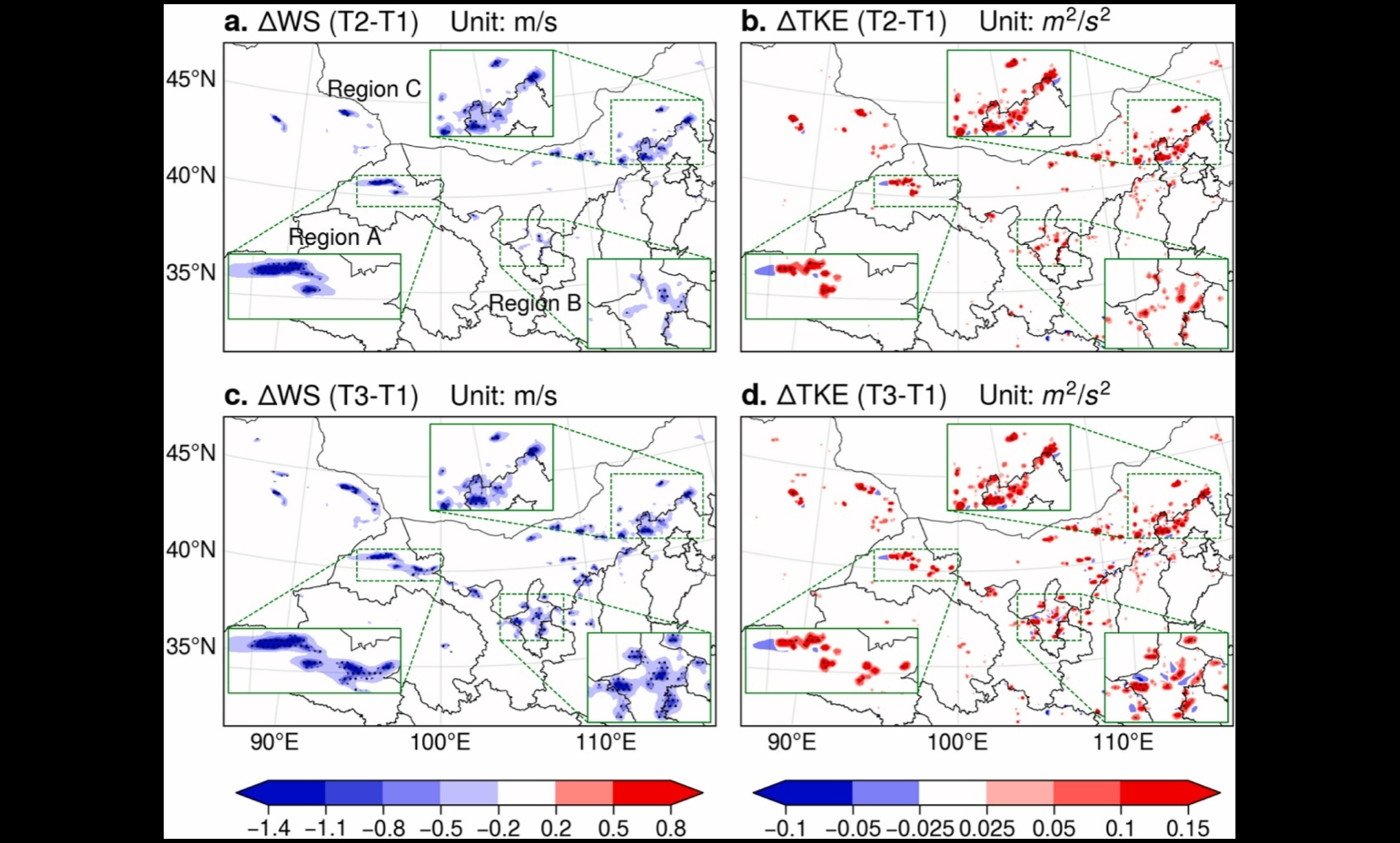
我国“三北”地区已建成全球规模最大的陆上风电场群,且装机容量仍在快速增长。数以万计的风力发电机持续从大气中提取动能,深刻改变下垫面动力粗糙度与大气边界层结构。面对这一规模空前、持续扩张的新型下垫面强迫,其潜在的区域气候效应及生态响应机理研究尚不明晰。 中国科学院西北生态环境资源研究院冰冻圈科学与冻土工程全国重点实验室余晔研究员团队,利用耦合风电场参数化方案与动态植被模块的区域气候模式,系统模拟评估了我国北方大规模风电场群的潜在环境影响,揭示了风电场群扰动局地及区域气候、进而影响植被生长的作用机制。 研究表明,风电场群在局地至区域尺度上可显著改变大气边界层动力过程,导致近地面风速减弱、湍流增强,而对热力场的直接扰动相对较弱。更为重要的是,风机阵列通过动力阻碍作用,可诱导低层水汽辐合、强迫气流抬升,间接增加对流有效位能,使北方农牧交错带夏季对流性降水增加,从而促进区域植被生长。模拟结果显示,上述气候生态效应会随风机尺寸和风电场规模的扩大而增强。 研究强调了大规模风电场群具有潜在正向生态效应。通过降低近地面风速、增加局地对流性降水,可有效抑制土壤风蚀、促进植被恢复。提出将风电基地建设与“三北”防护林工程深度融合,在防护林外围规划建设风电屏障带,构建“风电先行削弱风力,防护林带巩固屏障”的新型防护体系,为提升区域生态屏障韧性、推动风电开发与荒漠化防治协同发展提供了新思路。 相关研究成果以Potential impacts of large-scale wind farms on regional climate and vegetation in northern China: Insights from modeling studies为题,发表于国际权威期刊Energy。该研究得到内蒙古自治区“揭榜挂帅”项目、国家自然科学基金等的资助。 论文链接:https://authors.elsevier.com/a/1mbEA1H%7Ec%7EX4wV 大型风电场群对100米高度处年平均风速(a, c)和动能(TKE)(b, d)的影响 大型风电场群对100米高度处年平均气温的影响(a, c)白天,(b, d)夜间 大规模风电场群对夏季(a, b)总降水量、(c, d)对流性降水量及(e, f)非对流性降水量的影响 大规模风电场群建设前后植被覆盖度差异的空间分布(a, b)夏季,(c, d)秋季
2026-02-28